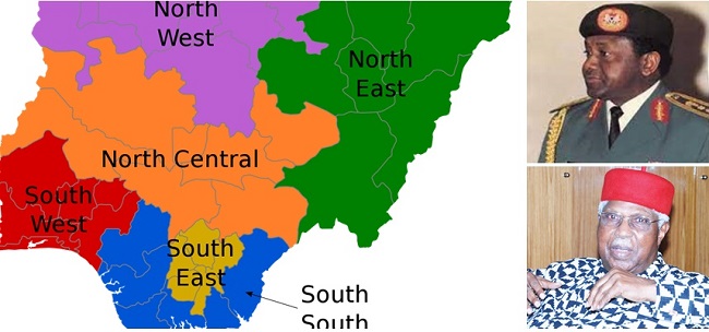
Adamawa, Bauchi, Borno, Gombe, Taraba, and Yobe States combined are sitting on 272,451km², thereby making the Northeast the largest geopolitical zone by land area in Nigeria.
Takeaway:
In terms of landmass, Northeast Nigeria is larger than Qatar, Jamaica, Lebanon, Luxembourg, Singapore, Gambia, Swaziland, and Israel combined
The zone faces the deadliest security challenges. Though, every part of Nigeria faces all kinds of insecurity.
The history of geo-political zones in Nigeria can the brilliant idea of Chief Alex Ekwueme, Nigeria’s former Vice President. But the division of the regions into zones was carried out by Sani Abacha.
From the North to South, are the land areas of the geopolitical zones in Nigeria
1) North East
The zone is predominantly occupied by the Fulani and Kanuri (in Borno). The zone which consists of Bauchi, Adamawa, Borno, Gombe, Yobe, and Taraba occupies 272, 451km², making it the largest in Nigeria.
In the zone, there are more than 100 minority groups. It is one of the most turbulent zones in Nigeria.
2) North Central
With 242,425km², the north-central is sometimes called the Middle belt is the second largest zone in terms of landmass.
It consists of six states (Kogi, Benue, Kwara, Niger, Nasarawa and Plateau), the Federal Capital Territory is also categorised as an entity under the zone.
The zone experiences the most tribal and inter-ethnic clashes in the history of Nigeria. At a time, it was alleged by some politicians in Benue that there were plans to cleanse minority groups.
3) North West
North West is the only region with seven states. It is also the most populated region in Nigeria according to 2006 data from the National Population Commission (NPC).
Using land area as a parameter, the North-West zone is the third largest with 193,088km². The zone consists of Zamfara, Sokoto, Kebbi, Katsina, Kano, Kaduna, and Jigawa states.
Surprisingly, the North-West is the most populated zone in Nigeria., according to the 2016 estimates by NPC and NBS. It is the zone with the highest number of council areas in Nigeria.
4) South-South
Sometimes called the Niger Delta region, the south-south sits on 84,587km² and produces the highest crude oil in the country.
The zone produces the highest revenue (oil revenue) to the Federal Government which the lawmakers, presidency, and state governments feed on.
The zone has six states consisting of Rivers, Edo, Delta, Cross River, Bayelsa, and Akwa Ibom. Only Cross River state is not an oil-producing state in the zone.
5) South West
Dominated by the Yoruba, the southwest is sometimes called the Yoruba region by some people in some parts of Nigeria.
South West is the 5th largest zone by land area, it covers 79,665km². It also has six states consisting of Ekiti, Ondo, Osun, Oyo, Lagos, and Ogun.
The zone is the headquarters of Nigerian financial institutions and the media while it remains it continues to be the zone that attracts more people from other zones.
6) South East
The South-East geopolitical has the lowest number of states in Nigeria. It has five states consisting Imo, Enugu, Ebonyi, Anambra, and Abia.
The states under this zone fall under the administration of the defunct Biafra Republic. The southeast is the only zone that has not produced a president after the gruesome murder of Thomas Umunnakwe Aguiyi-Ironsi on July 29, 1966, during a coup.
With 29,525km², the southeast zone is the smallest by land area. It’s the most business innovative zone in Nigeria
Recap:
| Geo-political zone | Land Area by km² | Position |
| North-East | 272, 451 | 1 |
| North-Central | 242,425 | 2 |
| North-West | 193,088 | 3 |
| South-South | 84,587 | 4 |
| South-West | 79,665 | 5 |
| South-East | 29,525 | 6 |


