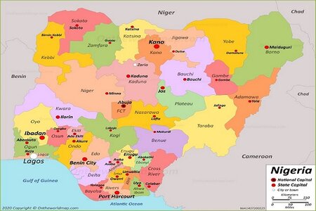
Nigeria houses 36 federating states that are also interwoven by boundaries. No state lives in isolation, they are interconnected with one other.
The inter-connectivity of the states which make Nigeria as one plays a significant role in the promotion of local trade and business.
In one of our guides, we shared with you 15 states in Nigeria that share international boundaries with other African countries and how it could promote cross-border trade.
When it is internal boundaries among the states, then we’ll be talking about local trade (more to come on that)
Nigerian States and Their Neighbours
| States | Neighbouring States | Comment |
| Abia |
|
|
| Adamawa |
|
It shares an international boundary with Cameroon |
| Akwa Ibom |
|
It’s very close to the Atlantic Ocean |
| Anambra |
|
|
| Bauchi |
|
The state boasts of major wildlife park like Sumu Wildlife Park. It has two distinctive vegetation zones: Sudan savannah and the Sahel savannah. |
| Bayelsa |
|
It is dominated by the Ijaw. The state houses beautiful waters of the Atlantic Ocean in its southern borders |
| Benue |
|
It also has an international border with Cameroon to the South-East. |
| Borno |
|
It has the highest number of land borders with foreign countries in Nigeria |
| Cross River |
|
It also shares borders with Cameroon and a beatiful views to the Atlantic Ocean |
| Delta |
|
It has a lot of coastline |
| Ebonyi |
|
It is dominated by Igbo ethnic group |
| Edo |
|
|
| Ekiti |
|
|
| Enugu |
|
|
| Gombe |
|
|
| Imo |
|
|
| Jigawa |
|
|
| Kaduna |
|
Kaduna also shares borders with the Federal Capital Territory, Abuja |
| Kano |
|
It has the highest number of local governments (44) in Nigeria |
| Katsina |
|
|
| Kebbi |
|
It also shares international boundaries African countries |
| Kogi |
|
Kogi has the highest number of boundaries with other states in Nigeria. It shares 10 land borders with other state. |
| Kwara |
|
It shares boundaries with the Republic of Benin |
| Lagos | Ogun state while others are covered by the Atlantic ocean | It shares an international border with Benin Republic |
| Nasarawa |
|
|
| Niger |
|
Niger is the largest state in Nigeria in terms of landmass |
| Ogun |
|
It shares diplomatic border with the Republic of Benin |
| Ondo | 1) Ondo
2) Kogi 3) Edo 4) Osun 5) Delta |
Part pf the state is covered by the Atlantic ocean. It is one of the oil-producing states in Nigeria |
| Osun | 1) Kwara
2) Ekiti 3) Ondo 4) Ogun 5) Oyo |
|
| Oyo | 1) Kwara
2) Osun 3) Ogun |
|
| Plateau | 1) Bauchi
2) Kaduna 3) Nasarawa 4) Taraba |
|
| Rivers | 1) Imo
2) Abia 3) Anambra 4) Akwa Ibom 5) Bayelsa 6) Delta |
|
| Sokoto | 1) Zamfara
2) Kebbi |
|
| Taraba | 1) Nasarawa
2) Benue 3) Plateau 4) Bauchi 5) Gombe 6) Adamawa |
|
| Yobe | 1) Bauchi
2) Borno 3) Gombe 4) Jigawa |
|
| Zamfara | 1) Kaduna
2) Katsina 3) Sokoto 4) Niger state |
|
| FCT, Abuja | 1) Kaduna
2) Niger state 3) Nassarawa 4) Kogi |
Abuja is the administrative headquarters of Nigeria |
How Nigeria’s Inter-State Boundaries Enhance Local Trade
Local trade is business transactions within a geographical territory within a country among the states or regions that make up the country.
It involves buying and selling between states, towns, or villages that involve the use of the country’s currency as a medium of transaction. In local trade, the national of the national currency e.g Naira isn’t impacted.
In international trade, the foreign exchange comes into play which could affect the value of the local currency.
Benefits
Some of the advantages of inter-state boundaries to local trade:
- Less transportation cost unlike cross-border trade which requires a huge cost of logistics
- It supports local job creation
- It enhances the production sector of Nigeria’s economy
- Local trade among states in Nigeria reduces dependency on foreign imports.
- It encourages inter-state partnership e.g rice production and sales between Kebbi and Lagos State governments.