Last updated on August 20th, 2023 at 02:54 am
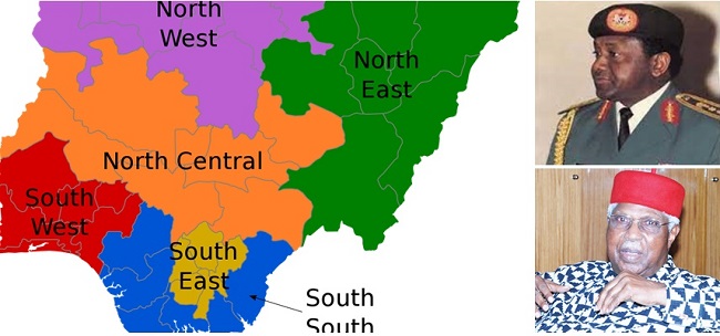
The six geopolitical zones in Nigeria are North East, North West, North Central (also known as Middle Belt), South East (comprises of majorly Igbo-speaking people of the defunct Biafra Republic ), South-South (also known as Niger Delta region), and the South West (majorly the Yoruba-speaking people).
Table of Contents
Creation of Nigeria’s six geopolitical zones
The idea for the creation of Nigeria’s six geopolitical zones began in the 80s with a top politician from the “former” Southern region.
According to history, he was worried about the continued political domination of the Hausa-Fulani who were hiding under the “one” North political gimmick to dominate other ethnic groups in the North and to the detriment of other parts of the country.
But the final creation of geo-political zones in Nigeria can be traced to the military regime of Sani Abacha in 1995.
So…
What are the six geopolitical zones in Nigeria?
The geopolitical zones in Nigeria and the number of states under each of them are:
North East:
North-east has six states. The states are:
- Borno
- Gombe
- Adamawa
- Yobe
- Bauchi
- Taraba
Northeast is the largest geo-political zone in Nigeria by land area. It is the most hit by the activities of Boko Haram and insurgency.
North West:
North-west has the highest number of states in Nigeria with seven states that include:
- Jigawa
- Kaduna
- Kano
- Katsina
- Kebbi
- Sokoto
- Zamfara
Apart from having the highest number of states, the region also has the highest number of council areas in Nigeria.
North Central (also known as Middle Belt):
- Benue
- Kogi
- Kwara
- Nasarawa
- Niger
- Plateau
- Federal Capital Territory
North Central is also as the Middle Belt. The region also has the highest number of Christians in the Northern part.
South East:
South East has the lowest number of states among the six geopolitical zones in Nigeria. There have been calls for more creation for the region for fairness and equality.
The states in South East region are:
- Ebonyi
- Abia
- Anambra
- Imo
- Enugu
South-east is the seat of Ohanaeze Ndigbo, an Igbo socio-cultural organization in Nigeria.
South-South (also known as Niger Delta region)
- Delta
- Edo
- Akwa Ibom
- Bayelsa
- Cross River
- Rivers
South West:
- Lagos
- Osun
- Oyo
- Ekiti
- Ogun
- Ondo
Note: The North-East is the largest zone by land area. The zone faces the deadliest attacks from terrorists like Boko Haram and ISWAP.


It’s educative for children when they need to know more about six geopolitical zone.
I like it it’s educative and correct
Nice one even though marginalization is still the order of the day.
It is good and informative